 |
| All these while I only have climbed hills and mountains which are less than 500m but today, I managed to set myself a new record by setting my footstep on the Malaysia's 6th most difficult mountain to climb which is known as Gunung Ledang. This great mountain is located between Tangkak and Segamat town. |
 |
| This is a little history about this 1276m tall mountain. Just click on the picture to enlarge to read. As for the fee, please scroll to the bottom for more detail. |
 |
| Here is the main entrance where I have started to see enthusiast climbers who already reporting in. You are required to fill in the form to acknowledge what items you bring and how many of them. This is to ensure you that you are not going to leave any rubbish in the mountain. |
 |
| This is the gathering area where they group any large group here for briefing. That day, there are two big groups which are almost more than 100 climbers. My group itself already consists of 60 climbers. |
 |
| This is the map where you get the rough idea of the way up and the way down from this mountain. Their checkpoints are listed there too. |
 |
| This is the starting point of our extreme journey. We do not know what is lying behind this road but I know it will never going to be easy especially I hate mountain climbing. Haha...you must be wondering why I am still here then. |
 |
| The first challenge is this "Laluan Tangga Mahligai". |
 |
| This is the "Laluan Mahligai" which has 786 steps which I have calculated personally. Hopefully I did not miscalculated it. Stairs usually is made as a warm up for the climbers but I hate stairs myself. It wasted more energy for me compare with the original path. |
 |
| After those freaking stairs, we have reached to our first checkpoint, Bukit Semput. At this point, you will start to see some people already start panting away. Some people will even started to say it is very hard. Well, you can't be walking up the stairs for 10 minutes and give up right? |
 |
| So off we go again. FYI, if you think you are lost and do not know which path you should take. Always look for a sign like this. This is a guide to let you know you are at the right path. After another 10 mins, we reached to the second check point which is called Hentian Meranti. There is no board for this checkpoint. |
 |
| The third checkpoint is "Laluan Kijang". At this stage you will see some people taking longer rest than it should be. The rest you should take is only 10-15 minutes only. Nothing more than that. The reason is the more rest you took, the harder you will feel to climb because your body has completely cool down. What you should do during the rest is find a place to sit to lose the tension over your legs and drink more water to recover the dehydration in your body. |
 |
| At the same time, enjoy the greens here. Take a deep breath and feel the nature around you. You will feel relax and forget that you are just completed 30% of the climb. LOL |
 |
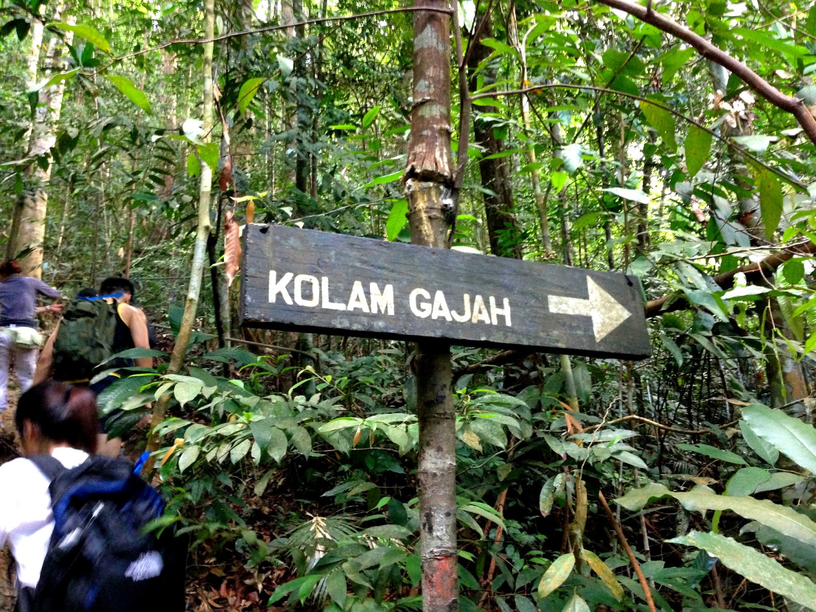
| Kolam Gajah is the fourth checkpoint where you will be diverted to another road. This is the camping site. |
 |
| Sungai Tiga Segi is the fifth checkpoint. When you are here, you already halfway of the mountain. 9 out of 60 in my group has decided to give up at this stage. What lies beyond here is 10 times more difficult than before. No joke. So take a good rest and start to grab something to eat to replenish your lost energy because you really need that later. |
 |
| This is the first water point and the only water point when you going up the mountain. If you only take 2 liters of water like me, you can start to refill here. |
 |
| Whether the water it is safe to drink or not, you judge yourself. You can see the white bubbles along the rock really unpleasant scene to see especially when you are going to use the water to drink. According to the guide, it is safe to drink because there are research on this water already. The rest of the convincing part will be solely up to you. Otherwise you have to bring at least 4 liters of water but think again, the more water you carry, the heavier your bag is and the more strength you will need to climb. So the decision is all up to you. |
 |
| If you have refilled all your water from Sungai Tiga Segi, you will start to cry at this "Laluan KFC". Sorry to disappoint you, there is no KFC waiting for you after this road which I also wish too as well. |
 |
| In my opinion, this is the hardest road compare with others because you are not just using the legs to climb but your pair of hands too. You are really CLIMB! Those ladders are already placed for you to climb. Without them, it is impossible to climb especially after raining. The rocks are so slippery. |
 |
| Everyone is starting to stop somewhere here in between to catch their breath. You will feel like this road has no end to it. The only motivation you will see is the sign pole telling you at what height you are now. At least you know you are already completed 70% of the road to the peak. It will be a shame for you to give up now. |
 |
| Checkpoint 6 is Gua Kambing. No cave here but this is where the ladies hate most. Your pair of hands are required more than your legs. There are a warning here which is barely able to see. The warning says what is lying beyond here is extremely dangerous. Please take extra precaution and be careful. This warning is making me so excited but for some of the ladies will start to say "Shit!" :D |
 |
| Here is the beginning. As you can see, guys with a better hand strength will prefer to use the rope to reduce the tension over their legs. As for the ladies, they will keep on using their legs so that's when they will choose the ladder. |
 |
| This is where the earlier lady will come out from. That's why it is called Gua Kambing. It is like a cave everywhere here. |
 |
| Here is more!!! Just want to clarify something with all the ladies reader here. I am not looking down on you girls because that's the reaction I got from our female climbers. I do believe there are some tough ladies out there who are up to these challenges. |
 |
| Brace! Brace! Brace! Let's continue to use all the available strength in your body to climb! This is really the genuine mountain climbing! |
 |
| If you think you can skipped the rope climbing earlier on, you are wrong. What you will see next is all using rope to climb!!! The girl has stuck there because she has no more strength with her hand to carry on. |
 |
This is the second compulsory rope climbing you have to go through. The technique of this rope climbing is:
1) Make sure the rope is between your legs.
2) Legs are only used to balance your body from tilting left or right. Do not attempt to use your legs to walk up the rock because you might slip!
3) Use the strength of your hands to pull yourself up! |
 |
| This is the mistake that is always done by the female climbers. As you can see, the rope is not in between and it is on the left and right of them. If one of them is off balance, she is going to hit one another and slip. Can you see the red shirt lady holding the rope? That rope is not for you to hold to climb up. This rope is for you to hold when you are tilting way to your right and hitting all those trees. This is not a precaution step taken by the management but it is because something has happened to a female climber who had done something like what these ladies did and hit the trees. If your hands have no more strength, take a rest. Do not feel pressure by the incoming climbers. There are other ropes for them to use. |
 |
| This is the last rope climbing with a beautiful scenery at the back. Good job everyone! |
 |
| I mean last rope climbing but not the final of this Gua Kambing road. This is the real final stage. Afraid of heights? Or feeling impossible to climb the ladders like this? Are they safe? Haha...Those should be the questions playing in your mind right when you see this. |
 |
| I have done it. Some ladders are quite wobbly so please climb one person at a time. |
 |
| I start to see scenery!!! |
 |
| Bukit Botak is the last checkpoint and most of us would not prefer to rest here because there are no shades here. Very hot! That's why it is called Bukit Botak. |
 |
| No longer tall trees means we are getting there. So keep it up for another 20 minutes! |
 |
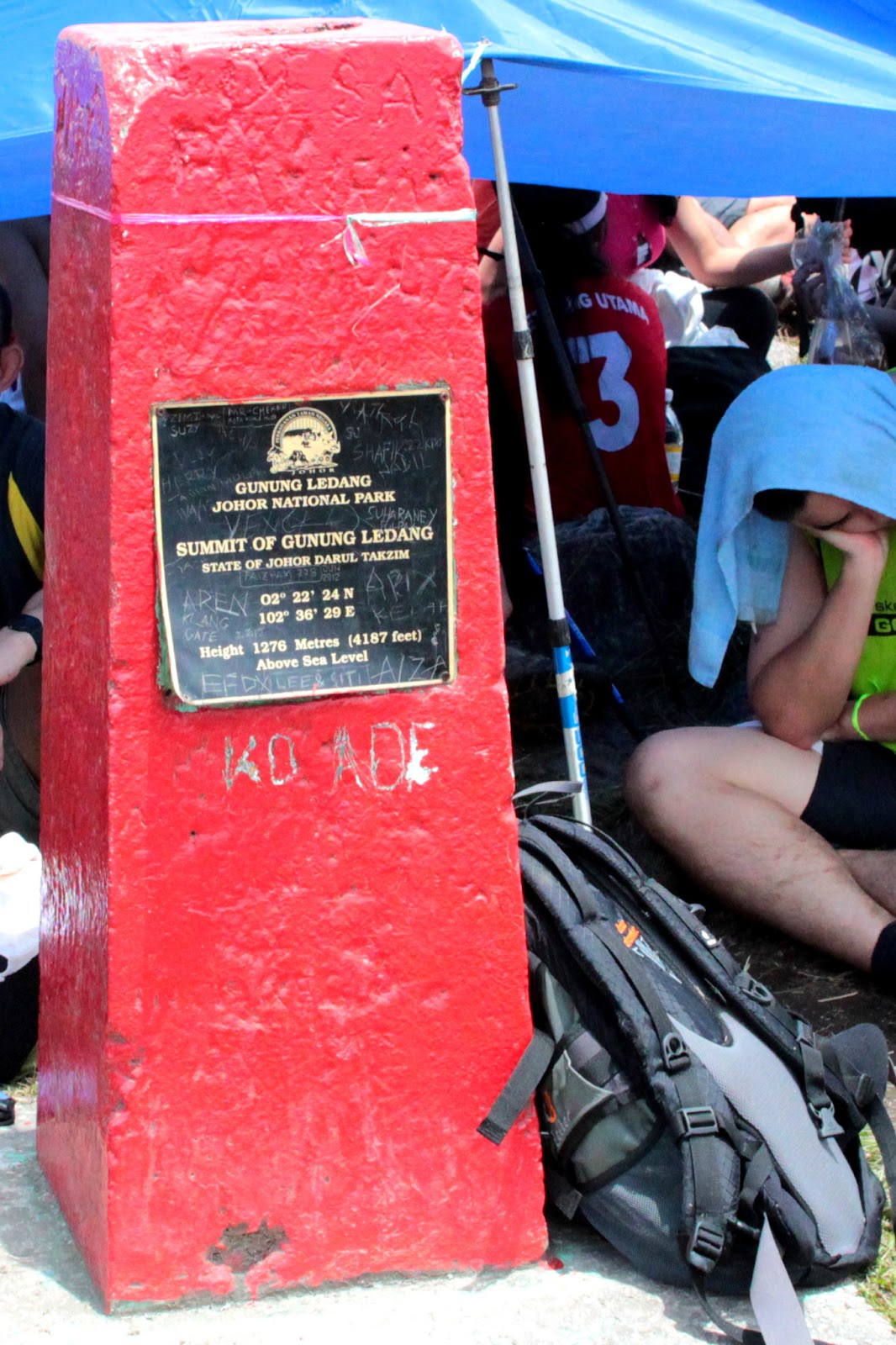
| Here we are and I am taking this picture from the second peak. That's the highest point of this mountain. |
 |
| That's where I am from and most people rather to stay there because there are some shades. but the peak does not have any. |
 |
| Congratulations to me! I am already at the peak! I feel proud of myself for able to do this. It took me 4 hours inclusive resting at the checkpoint 1, checkpoint 2, checkpoint 3, checkpoint 5 and checkpoint 6. |
 |
| This is what we usually see from a plane but this time I am not! I am within the clouds! The clouds are so breezing cool!!! |
 |
| The clouds are all around the mountains. I like this temperature a lot. |
 |
| The cloud started to clear off and I am starting to see something. |
 |
| Weee~~~~ A pleasant sight of mother nature! |
 |
| Some climbers claimed that can see Malacca from here if it is not cloudy. But I like the cloud! Without the cloud is freaking hot up here! The sun is like just above our skin! |
 |
| There is a tv/radio station here but not mobile station. So the reception is quite poor here for certain mobile operators. Celcom works the best here! |
 |
| No shades? Bring your own and set it up like this! |
 |
| Maggi Cup??? I am hoping to have a cup of that too now!!! Looks so delicious! |
 |
| After 1 hour of enjoying my moments on the the peak, it is the moment to climb down. It is much more harder than climbing up because you have used most of your strength to climb up already. 1 hour rest is just not enough to recover you from fatigue. So very lack of pictures when climbing down because my both hands has to use glove to hold trees and rock to climb down. I slipped thrice in this session. So please be careful. |
 |
| After 20 minutes, you will find another source of water. This is the final one and start to replenish your water supply now. The water is cold and pretty good to drink despite the large white bubbles which I have pointed to you with a red arrow above. At this point, you just need to survive. Who cares if the water is polluted or not. |
 |
| After 2 hours climbing down, here are the aftermath of my leg with scratches everywhere especially when you are wearing shorts. Overall experience was great despite legs and hands sore for a week. |
Things to wear and bring:
1) Wear long or short pants
2) Small towel
3) Raincoat
4) Hiking Shoes/Socks
5) Water Bottle - at least 4 liters if you do not want to drink water from the mountain.
6) Torchlight or headlight
7) Energy bar or snacks
8) Backpack
9) Some medication such as medical plaster, cooling gel to avoid leg cramps.
10) Hiking stick
11) Gloves
12) A new set of clothes
13) Toiletries if you planned to bath there.
FYI, their bathrooms are badly maintained. So I would advised you to go back to your hotel or where you are from for a proper bath.
Fees & Charges:
Registration Fee: RM3.00/pax
Entrance fee: RM13.00/day (myKad), RM23/day (foreigners)
Parking: RM2.00 per car + RM1.00/pax (RM0.50/pax for kids 4-12 years old)
Tour guide fee: RM140 (optional)
Total Damage: RM55.00
Freakout Level: 5/5
Ambiance: 4/5
Service: 3/5
Price: 2/5
Public Amenities: 1/5
Recommended?: Yes
Perbadanan Taman Negara Johor
Aras 1, Bangunan Dato’ Mohammad Salleh Perang,
Kota Iskandar, 79795 Nusajaya,
Johor Darul Ta’zim, Malaysia
Tel: 607-266 1301
Opening Hours: 8.00am - 7.00pm (daily)


Comments
Post a Comment